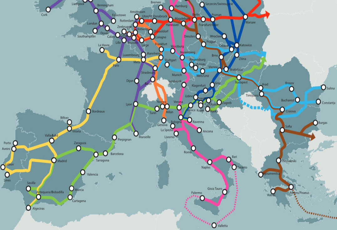
Luka Rijeka is located in the strategic EU transport route (TEN – T Mediterranean corridor) connecting to the „Baltic – Adriatic“ route
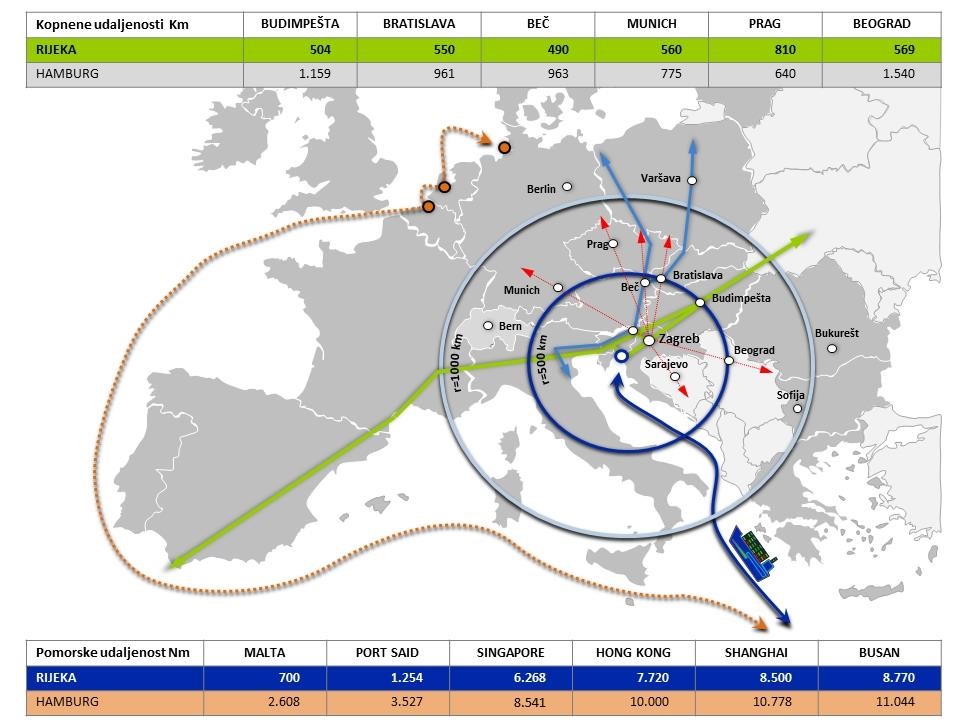
Luka Rijeka provides the shortest maritime link between the countries of the Central and Eastern Europe and overseas countries
As a part of TEN-T transport network, Luka Rijeka is important for land-locked countries (Hungary, Austria, Slovakia, Czech Republic, Serbia, BiH) and is in good position to take advantage of the location
The EU and Croatia are strategically and operationally supporting investment in port and railway infrastructure that raise the transport capacity of that route. The EU Funds will act as significant support to the investment cycle of both port and railway sector
The liberalization of the railway operators market and entry of the private capital into port operations raise their efficiency as well as the competitiveness of Rijeka traffic direction
Geostrategical position, market
Luka Rijeka is part of the northern Adriatic port cluster along with the ports of Koper, Trieste, Venice, Ravenna, Monfalcone and Chioggia. The system fulfills the import and export needs of the gravitational area which includes Italy, Switzerland, Germany, Austria, Croatia, Slovenia, Bosnia and Herzegovina, Serbia, Hungary, Slovakia, Czech Republic and Poland.
The northern Adriatic ports compete with large clusters of the northern ports (Rotterdam, Amsterdam, Antwerp, Ghent, Hamburg and Bremen), Baltic ports (Rostock, Gdansk, Gdynia, Swinoujscie and Szczecin), Black Sea ports (Constanta, Varna and Burgas), South Adriatic ports (Ploče, Bar and Drač) and the Aegean ports (Thessaloniki and Piraeus).
Besides that, the largest European inland waterway - the „Rhine-Main-Danube Channel“ passes through this gravitational area.
F or many years, Luka Rijeka has been an important transit port for hinterland countries, mainly in Central, Central Eastern and Eastern Europe. In this large area, the strategic goal are two groups of countries in the group of priority and secondary markets, followed by the third markets and wider gravitational hinterland.
Priority markets on the central line Croatia-Hungary-Slovakia
Secondary markets in the northern line Austria-Czech Republic-Poland and the southern line BiH-Serbia
Third zone consists of the northern Adriatic ports (Italy and Slovenia)
Wider gravitational area of western Romania, western Ukraine and southern Germany
Compared to the Northern Sea, the Northern Adriatic maritime route has a great nautical advantage for trade of goods over the Suez Canal from the Middle and Far East. For ships from the Far East, the route is shorter by 2.000 Nm and shortens cargo transport for approx. 6 days of sailing. With shorter time and lower transport costs, the Northern Adriatic route also contributes to significant savings in CO2 emission.
Regarding the destination (emissive) markets that with the gravitational hinterland of the port of Rijeka, realize the trade exchange, the most significant ones are through the Suez Channel:
North Africa (Morocco, Algeria, Tunisia, Libya, Egypt, Sudan)
Eastern Mediterranean - Levant (Turkey, Syria, Lebanon, Jordan, Israel)
Middle East (Saudi Arabia, Bahrain, Qatar, United Arab Emirates, Oman, Yemen, Kuwait, Iraq, Iran and Afghanistan)
Far East (China, Hong Kong, Taiwan, Japan and South Korea)
Indian Subcontinent (India, Pakistan, Bangladesh and Sri Lanka)
South East Asia (Indonesia, Philippines, Thailand, Vietnam, Malaysia and Singapore)
East Africa (Ethiopia, Kenya, Tanzania, Mozambique and the converging land-locked African countries)
Markets that do not use the Suez channel (Western, i.e. Atlantic route) also use the traffic route across the northern Adriatic cluster, but are more oriented towards the European Northern Sea Cluster.


